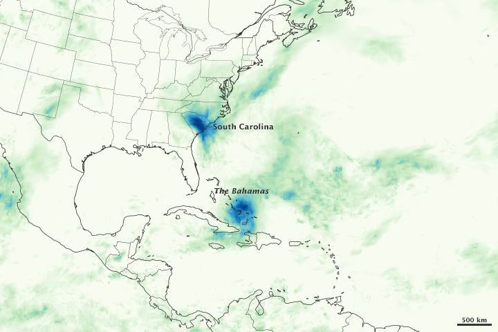
On October 3rd, East Coast residents were relieved to hear that Hurricane Joaquin, which had been hurtling towards the U.S., was no longer a threat. According to meteorologists, the hurricane that was weakened to a category 3 after battering the Bahamas, would likely remain out to sea instead of ramming the coastline as had been previously thought.
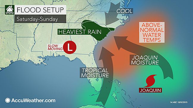
While that certainly turned out to be true, Joaquin still managed to 'collaborate' with other systems already in the area to create the perfect storm - One that deluged many East Coast states with unprecedented rains. Though the storms impacted residents all the way from Georgia to Delaware, it was South Carolina that bore the brunt of the system's wrath.

The soggy weather that began on Thursday, October 1st, escalated sharply on Saturday. Charleston recorded 10.7 inches of rain, the city's wettest day ever according to the National Weather Service. And it was far from over! By Sunday night, many areas had seen more that 20 inches of rain. In addition to the heavy rains, the coastal towns were also impacted by the high ocean tides that peaked at 8.29 feet - The highest water level experienced in Charleston Harbor since Hurricane Hugo made landfall in 1989.
By the time the rainfall began to taper off late Monday, it had managed to set records all over the state and flood entire towns. For many locations, the historic downpour qualifies as a 1,000-per year rain event. This means that in any given year there is a 1 in 1,000 chance of encountering rainfall totals of this magnitude.

So what caused the historical rain? According to experts, it was the combination of several weather patterns that came together in just the right way to produce the downpour the size of which has never before been experienced in this part of the Southern United States. Meteorologists say a strengthening non-tropical storm in the south, a strong area of high pressure in Canada and converging tropical moisture from Hurricane Joaquin all joined forces to create the exceptional rains.
With the worst storms behind them, South Carolina residents are now trying to deal with the impact of the downpour that breached several dams and caused massive flooding. As of October 11th, about 260 roads and 125 bridges remained closed across the state. The residents of Lowcountry are particularly at risk as the flood waters across the state start to move in their direction, as they make their way to the ocean. Thousands remain without power, and many are still in shelters waiting for flood waters to recede from their homes.

At South Carolina's capital city Columbia, utility workers are working round the clock to repair the canal that the town uses to bring in drinking water after a breach nearly drained the waterway. They also have to restore dozens of broken water lines. Meanwhile, residents are being asked to boil all drinking water.
But despite the challenges, the residents are trying to get back to normal life as much as possible. After an unscheduled week off, most school districts are now open, albeit on a reduced schedule to allow buses to drive in the daylight. Organizers of the annual South Carolina Fair in Columbia plan to begin as scheduled on Wednesday. Authorities believe they will have all the infrastructure repaired in time for the thousands of visitors that come to this popular event each year.
The one silver lining is that South Carolina's drought that just last week had been plaguing 73% of the state now appears to be over. The only area that is still dry is the extreme southern part that received less than three inches of rain.
Do you live in an area that experienced this severe weather? If so, please share your experience with us by adding your comments below.
Resources: cnn.com, washingtonpost.com,extinctprotocol.wordpress, weather.com,accuweather.com